Update as of 5 PM Sunday:
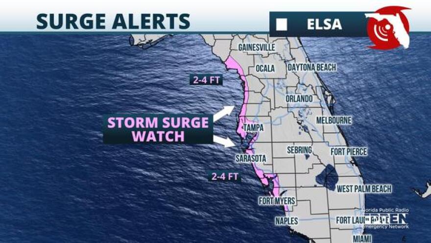
A Tropical Storm Watch has been extended northward and includes much of the Florida west coast to the Anclote River. The Fort Myers, Sarasota, and Tampa areas are included Tropical Storm Watch. In addition, a Storm Surge Watch has been issued from Bonita Beach northward to the Suwannee River, including Tampa Bay.

Tropical Storm Warnings continue for the Florida Keys from Craig Key westward, and Watches continue for the remainder of the Keys to the east of Craig Key.
Water levels may rise to between 1 and 3 feet above normally dry ground in places from the middle and lower Keys and northward to Bonita Beach. Water levels may increase to 2 to 4 feet above dry ground on Tuesday from Bonita Beach northward to the mouth of the Suwannee River, including Tampa Bay.
Original Story from 11 AM Sunday:
Tropical Storm Warnings were issued late Sunday morning for the Florida Keys from Craig Key westward to the Dry Tortugas. Tropical Storm Watches have been expanded northward to cover a large area of South Florida. The watches include the Keys from east of Craig Key northward, including Florida Bay. A Tropical Storm Watch is also in effect from Flamingo north to Bonita Beach, including Naples and Marco Island.
Tropical Storm Elsa's torrid pace slowed considerably Sunday while it brings heavy rain and tropical storm conditions to Jamaica and Cuba.
The storm's motion in excess of 30 mph early Saturday morning had slowed down to a little more than 10 mph Sunday morning. Tropical cyclones, on average, move between 10 and 15 mph, so Elsa is now moving at a pace that is more common. Tropical Storm Warnings continued over Jamaica and a large portion of Cuba, where tropical storm conditions are expected to continue on occasion through Monday. Flash flooding and mudslides are possible on the mountainous islands and on Haiti, where 4 to 8 inches of rain is expected. Isolated areas were expected to receive as much as 15 inches.
The storm itself has become disorganized in the face of strong wind shear and its close pass to Haiti on Saturday. Its interaction with Cuba Sunday night and Monday is likely to cause additional weakening before it emerges over the Florida Straits Monday night. A small amount of re-strengthening is possible in the Gulf of Mexico, but strong wind shear is expected to keep the heaviest rain and winds east of the circulation center and most likely prevent Elsa from regaining hurricane strength.

The first rain bands from Elsa over the Florida Keys are expected Monday afternoon, where Tropical Storm Watches remain in effect. Tropical storm force winds are likely, particularly over the lower and middle Keys late Monday afternoon into Monday night. The slower storm motion means any tropical storm force winds over South Florida would hold off until overnight Monday or at first light on Tuesday, favoring the Gulf side.
Tropical storm conditions are possible as far north as Tampa and Orlando Tuesday evening, and then from the Nature Coast into North-Central and Northeast Florida overnight Tuesday into Wednesday. If tropical storm winds were to occur, they would be more likely on the Gulf of Mexico side of the peninsula Tuesday night, but would then shift to Florida's First Coast on Wednesday as the storm turns more toward the northeast.
Heavy rainfall is likely to be the greatest impact from Elsa. Widespread rainfall of 2 to 5 inches are forecast directly from Elsa, which may result in areas of urban flash flooding and minor river flooding over the Florida Peninsula early this week. A separate front has been producing heavy rainfall over the holiday weekend, particularly from the Tampa/St. Petersburg areas northward to Orlando, Gainesville, and Jacksonville metro areas. These areas have had almost twice their average rainfall since the beginning of June and additional rain from Elsa would increase the possibility of flooding, especially in these areas.
Conditions are likely to improve by Wednesday evening as Elsa begins to move toward the eastern Carolinas.
Copyright 2021 WUFT 89.1. To see more, visit WUFT 89.1. 9(MDAyMTYyMTU5MDEyOTc4NzE4ODNmYWEwYQ004))

