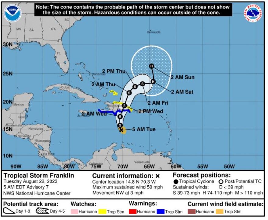
The mercurial nature of weather can be seen in the constant changes among the current five systems being watched in the Atlantic and Gulf of Mexico since last week. A new tropical storm, Harold, formed overnight and headed to Mexico and the Southwestern U.S.
For the North Atlantic, Caribbean Sea and the Gulf of Mexico/Active Systems:
The National Hurricane Center is issuing advisories on Tropical Storm Franklin, located over the east-central Caribbean Sea, on Tropical Depression Gert, located a few hundred miles east-southeast of the northern Leeward Islands, and on recently upgraded Tropical Storm Harold, located over the western Gulf of Mexico.

Tropical Storm Franklin:
Although deep convection has increased overnight, Franklin remains a somewhat disorganized tropical cyclone. Statistical guidance indicates that Franklin will remain in a harsh shear environment for next several days, and interaction with the higher mountainous elevations as it traverses Hispaniola should further disrupt the storm's circulation.
By the weekend, however, the global models are in good agreement that the upper wind pattern will become more conducive for strengthening and the official forecast shows Franklin become a hurricane over the southwest Atlantic by day 4.
Toward the end of the forecast period, Franklin is expected to turn generally northward as a mid-latitude shortwave pulse moves off of the eastern seaboard on Sunday and strengthens the weakness over the western Atlantic.
Tropical Storm Harold:
Air Force Hurricane Hunter wind observations indicate that the cyclone strengthened to a tropical storm earlier this morning.
However, the circulation is not very well defined and the low-level center is somewhat elongated from south to north. Imagery from the Brownsville, Texas, WSR-88D radar shows broad cyclonic turning, with curved rain bands moving onshore of the south Texas coast.
Harold is embedded in strong deep-layer easterlies on the southern periphery of a large anticyclone over the east-central United States. As a result, the cyclone is moving fairly briskly toward the west-northwest at around 285/16 kt. This general motion should continue through tonight, and the official forecast is quite similar to the previous one.
The system still has a short time to strengthen over the warm Gulf waters, and the latest guidance shows slight strengthening within the next 12 hours. This is reflected in the official forecast. Since the cyclone does not have a well-defined inner core, however, rapid intensification is not likely before landfall.
Tropical Depression Gert:
Gert is a very disorganized system and may no longer have a closed circulation.
1. Eastern Tropical Atlantic (AL92):
Disorganized showers and thunderstorms located a few hundred miles west of the Cabo Verde Islands are associated with a tropical wave. Environmental conditions appear generally conducive for gradual development of this system, and a tropical depression could form later this week while it moves west-northwestward across the eastern tropical Atlantic.
* Formation chance through 48 hours...low...30 percent.
* Formation chance through 7 days...medium...60 percent.
2. Central Tropical Atlantic:
The remnants of former Tropical Storm Emily are located over the central tropical Atlantic several hundred miles east-northeast of the Leeward Islands with limited associated shower activity.
Environmental conditions could become more conducive for re-development of this system late this week or this weekend when the system moves northward over the subtropical central Atlantic.
* Formation chance through 48 hours...low...near 0 percent.
* Formation chance through 7 days...low...20 percent.
WGCU is your trusted source for news and information in Southwest Florida. We are a nonprofit public service, and your support is more critical than ever. Keep public media strong and donate now. Thank you.

