A flood watch has been issued for Collier, Glades and Hendry counties beginning at midnight Monday and running through Wednesday evening.
The National Weather Service in Miami issued the watch for most of the southern end of the state from the Collier line over to Palm Beach County.
The NWS forecasters said impacts will include excessive runoff may result in flooding of rivers, creeks, streams, and other low -- lying and flood — prone locations. Flooding may occur in poor drainage and urban areas.
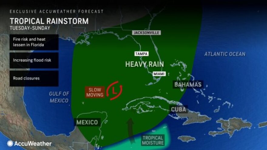
Enhanced tropical moisture is expected to pool across South Florida beginning on Tuesday.

That moisture will result in periods of heavy rain. High rainfall rates and slow moving storms will result in flooding concerns, especially in urban and poor drainage locations.
Rainfall totals from Tuesday Morning through Wednesday evening are forecast to be 5 - 8 inches across Southwest Florida and the Lake Okeechobee region, and 2 - 5 inches over the East Coast Metro, with locally higher amounts possible. Additional heavy rain is possible later in the week.
In Lee County, the forecast called for steady precipitation all week, from 80 to 100 percent most every day. Total rain accumulation for Monday and Tuesday were forecast up to six inches.
Charlotte, Sarasota and counties north are forecast with less significant amounts and percentages of rain.
Accuweather forecasters had a slightly different outlook: “The bullseye is on southwest Florida along the Gulf Coast,” said AccuWeather Chief On-Air Meteorologist Bernie Rayno. “Severe weather will be limited. The big threat is going to be flooding. Warm air at the surface and cold air aloft makes for a very unstable atmosphere. With a dip in the jet stream this far south, it’s going to pull a lot of tropical moisture north into Florida.”
The Accuweather forecast said tropical downpours were expected to arrive in South Florida on Tuesday. AccuWeather is forecasting 8 to 12 inches of rainfall across much of Southwest Florida through Sunday. Some spots could see up to 22 inches of rain this week, according to the AccuWeather Local StormMax.

“We are concerned about a ‘wall of rain’ inundating Florida this week,” said AccuWeather Lead Long-Range Forecaster Paul Pastelok. “While we can’t rule out an organized tropical depression or storm, the impact will be similar due to the rounds of tropical downpours.”
Rainy season checklist
The South Florida Water Management District reported that it was prepared for potentially heavy rainfall throughout the week and would actively monitor, manage and adjust its primary water management system throughout the entire rain event.
Over the next five days, rainfall is expected to be significantly above average for this time of year. There is a strong potential for flooding in low-lying areas, areas with poor drainage, and coastal areas impacted by high tides
Much of the Central and Southern Florida region has an interconnected water management system, and flood control is a shared responsibility between county/city governments, local drainage districts, communities (including Homeowner Associations or HOAs), and the District. In addition, the District will work with drainage partners to provide as much drainage as possible in impacted areas.
WGCU is your trusted source for news and information in Southwest Florida. We are a nonprofit public service, and your support is more critical than ever. Keep public media strong and donate now. Thank you.


