-
A developing El Niño could affect Florida in two major ways: fewer Atlantic hurricanes, followed by a wetter, stormier winter with greater severe weather risk. NOAA says El Niño over a 60% chance of developing in summer 2026, with a 1-in-3 chance of becoming strong by late fall.
-
La Niña officially emerged in September 2025 and lasted until April. Neutral conditions are present, but an El Niño is expected to emerge later in 2026.
-
Colorado State University is one of the most highly revered names in hurricane forecasting, and for Florida, that matters. Here’s why a landlocked university has become so influential for a state that sees more hurricane hits than any other.
-
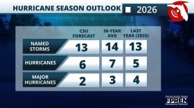
Colorado State University’s 2026 Atlantic hurricane season outlook calls for below-normal activity across the Atlantic basin due to a likely transition into an El Niño.
-
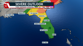
A strong cold front will push through Florida, bringing a chance for severe storms, much-needed rain, and a brief drop in temperatures. Some relief to our A/C units.
-
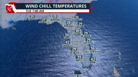
Cold temperatures for two nights to start the week, but the coldest night will be Monday night into Tuesday. Strong winds and low humidity levels will increase the wildfire risk across Florida as the extreme drought worsens.
-
-
-
Florida's severe weather week is here. And it's a great reminder that weather disasters can happen all year long - not just during hurricane season. From extreme cold to extreme heat, and everything in between, now is a great time to make sure you're prepared.
-
Punxsutawney Phil has predicted six more weeks of winter after emerging from Gobbler's Knob in western Pennsylvania.
Play Live Radio
Next Up:
0:00
0:00
Available On Air Stations


