Updated on Aug. 23 at 4:30 a.m. ET
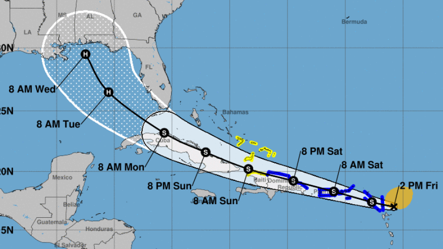
Two tropical systems — Marco and Laura — are heading toward the Gulf of Mexico, and both are expected to become hurricanes before they near the U.S. mainland early next week, according to the National Hurricane Center.
The current forecast sees both storms hitting the near Louisiana, with Marco arriving on Monday and Laura on Wednesday.
"If that were to occur, it would be first time on record that the Gulf of Mexico has had 2 hurricanes at the same time," meteorologist Philip Klotzbach says via Twitter. According to Kotzbach, Louisiana has recorded multiple hurricane landfalls in one calendar year only four times since 1851, with the shortest recorded time in between landfalls recorded at around 17 days in 1860.
"There are only a few times in recorded history where two tropical cyclones have shared the Gulf of Mexico," according to the Weather Prediction Center. "Flash (wayyy) back to 1933 to find a similar example," it added, referring to a time when a hurricane and a tropical storm coincided in the Gulf.
The two developing systems are currently hundreds of miles apart, but their paths are expected to parallel each other in the Gulf and even partially overlap. Their landfalls will likely be divided by hours, not days. But it's not yet certain whether both will hit the shore as hurricanes, or whether their paths might diverge.
Tropical Storm Laura, which strengthened into a named storm Friday morning, is near the eastern portion of the Dominican Republic. Marco is expected to be at or near hurricane strength when it approaches the central Gulf Coast as a hurricane on Monday.
Tropical Storm Laura is causing alerts in Puerto Rico, the Virgin Islands and Hispaniola, where it will drop heavy rain on its way toward Cuba and the Gulf.
"This rainfall could cause flash and urban flooding," the hurricane center says.
Laura is forecast to strengthen as it moves over the Gulf of Mexico, bringing a storm surge to portions of the U.S. Gulf Coast by the middle of next week.
Marco is a more immediate threat, and may become a hurricane within the next 24 hours. A hurricane watch is in effect from Intracoastal City, La., to the Mississippi/Alabama border. The area includes New Orleans.
The 2020 Atlantic hurricane season is already setting records with named storms forming at a pace never seen before. The latest estimates from the National Oceanic and Atmospheric Administration call for nearly twice the normal number of named storms in 2020.
Climate change has been linked to the more frequent occurrence of major hurricanes globally as well as the rising number of hurricanes in the Atlantic. In addition to strong winds, many of the most dangerous storms in recent years have brought tremendous amounts of rain – creating new threats to people and infrastructure far inland from the coast.
Copyright 2020 NPR. To see more, visit https://www.npr.org. 9(MDAyMTYyMTU5MDEyOTc4NzE4ODNmYWEwYQ004))


