-
 Charlotte County Economic Development, in partnership with local chambers and regional organizations, will host a free Business Hurricane Season Preparedness Webinar at noon on May 6 to help local businesses prepare for, respond to, and recover from severe weather events. The virtual session will be held via Microsoft Teams and is open to businesses across the region.
 -
 A developing El Niño could affect Florida in two major ways: fewer Atlantic hurricanes, followed by a wetter, stormier winter with greater severe weather risk. NOAA says El Niño over a 60% chance of developing in summer 2026, with a 1-in-3 chance of becoming strong by late fall.
 -
 A 1,733-acre wildfire was being fought in the Picayune Strand State Forest in Collier County Monday afternoon. The fire was south of Alligator Alley and prompted a warning from the Florida Highway Patrol.
 -
 La Niña officially emerged in September 2025 and lasted until April. Neutral conditions are present, but an El Niño is expected to emerge later in 2026.
 -
 Colorado State University is one of the most highly revered names in hurricane forecasting, and for Florida, that matters. Here’s why a landlocked university has become so influential for a state that sees more hurricane hits than any other.
 -
 Highlands county burn ban extended because of extreme dought
 -
 A free Community Conversation on Hurricane Preparedness event is plannedfrom 9a.m.to 1 p.m. on Saturday, April 11 at Riverview High School inSarasota.
 -
 Severe, extreme, and exceptional drought expands across Florida as temperatures remain warm and high pressure keeps showers and storms focused only on some areas.
 -
 Fort Myers Broadcasting Company, which operates WINK News, filed a breach of contract and breach of fiduciary duty lawsuit Wednesday against its former weatherman Matt Devitt alleging he gambled during work and violated a non-compete clause.
 -
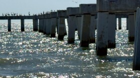 In 2022, according to visitfortmyers.com, there were more than 4.4 million visitors, with the top three local attractions drawing crowds to the county being the beaches themselves at 66%, the Fort Myers Beach Pier at 36%, and the Sanibel Lighthouse at 26%. However, the year after Hurricane Ian, that number fell to nearly 3 million visitors. The pier’s visitation rate dropped to 15% while the beaches remained No. 1 at 51%. But now, with the promise of a new and improved pier on the horizon, those stats are starting to rebound.

© 2026 WGCU News
PBS and NPR for Southwest Florida
Play Live Radio
Next Up:
0:00
0:00
Available On Air Stations


