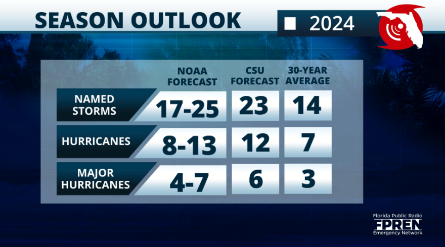
So far there have been four named tropical systems in the 2024 Atlantic hurricane season, and if Colorado State University´s latest forecast verifies there would still be 19 storms to go.

Debby, the fourth named storm of the season made landfall in Florida as a hurricane. Luckily the dry air infiltrated this system not allowing it to intensify to a major system, but the biggest concern was and still is the amount of water that falls from it.
Parts of Florida received 15 inches of rain. South Carolina is dealing with some spots approaching 20 inches and the system is about to come back over South Carolina for round two.
Here is the latest 4-day rainfall reports (totals since Saturday morning) associated with #Debby across the Southeast. For additional observations, please refer to our latest Storm Summary (https://t.co/jrRqqo3AqT) pic.twitter.com/7R0JgNn53Z
— NWS Weather Prediction Center (@NWSWPC) August 7, 2024
As it is common after the system exits, drainage and the shift in winds push the rivers' and creek's water downstream, often bringing delayed flooding to areas near bodies of water, and if those areas are still dealing with flooding it could be weeks before the water recedes.
This is the situation happening across parts of North Florida with major flooding happening in some spots along the Santa Fe River and St. Marys River.
A moderate flood in many other spots along the Santa Fe and Suwannee Rivers. The long-range models show that Santa Fe River at Fort White to reach its most critical level by Friday night, and then gradually drop to the moderate stage by next Wednesday.

What's the latest in the CSU forecast?
Meteorologists and experts from Colorado State University release a couple of updates throughout the hurricane season. The latest forecast is the last one of this season and will release a verification of this forecast in November 2024.
The latest forecast knocked down the total number of storms by 2 but kept the same for the hurricanes and major hurricanes that could form.
Dr. Phil Klotzbach, leading the hurricane forecasts, says that there is high confidence that this will be a very active season. Water temperatures in the main development region of the Atlantic continue to be above average, even waters closer to the U.S. (as you can see in the picture below) continue to be extremely warm, and there is the chance for La Niña returning during the peak of hurricane season, which would enhance tropical storm formation due to the wind shear becoming more relaxed.

It only takes one storm to make it a busy season for you and your loved ones. Make sure to review your hurricane plans and that all your documents are in order. Please do not compare storms. Each storm is different and carries different hazards. Also, consider any recent events that might be putting your area at more risk or more vulnerable.
Copyright 2024 Storm Center


