-
Highlands County is driest county south of Orlando.
-
For Florida, hurricane season prep starts with understanding that not all risk looks the same. Hurricane impacts can include storm surge, inland flooding, destructive wind, tornadoes, and more.
-
A burn ban automatically went into effect for Sarasota County due to local drought conditions and an increased chance of fire hazards.
-
A wildfire being identified as the Jetport fire is located near the Alligator Alcatraz detention facility in eastern Collier County.
-
A developing El Niño could affect Florida in two major ways: fewer Atlantic hurricanes, followed by a wetter, stormier winter with greater severe weather risk. NOAA says El Niño over a 60% chance of developing in summer 2026, with a 1-in-3 chance of becoming strong by late fall.
-
A 1,733-acre wildfire was being fought in the Picayune Strand State Forest in Collier County Monday afternoon. The fire was south of Alligator Alley and prompted a warning from the Florida Highway Patrol.
-
North Port is hosting a Hurricane Expo from 9 a.m. to 1 p.m. on Saturday, April 18 at the George Mullen Activity Center, 1602 Kramer Way.
-
La Niña officially emerged in September 2025 and lasted until April. Neutral conditions are present, but an El Niño is expected to emerge later in 2026.
-
Colorado State University is one of the most highly revered names in hurricane forecasting, and for Florida, that matters. Here’s why a landlocked university has become so influential for a state that sees more hurricane hits than any other.
-
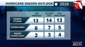
Colorado State University’s 2026 Atlantic hurricane season outlook calls for below-normal activity across the Atlantic basin due to a likely transition into an El Niño.
WGCU is your trusted source for news and information in Southwest Florida. We are a nonprofit public service, and your support is more critical than ever. Keep public media strong and donate now. Thank you.


