-
 Freeze alerts are already in effect for the Panhandle and North Florida as temperatures are expected to drop to the lowest they've been in over a year.
 -
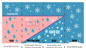 Residents of the Panhandle woke up to an uncommon sight on Tuesday morning: Snow flurries and freezing rain. The conditions were brought on by the passage of a strong cold front through the Mississippi Valley and the Southeast.
 -
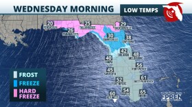 Sub freezing lows are forecasted for the Panhandle and North Florida on Wednesday morning. Wind chills in the 30s are expected as far south as Tampa and Orlando.
 -
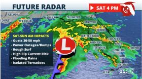
 Just days after strong storms and numerous tornadoes across the Panhandle, the risk for severe thunderstorms returns
 -
 Multiple rounds of dangerous thunderstorms are expected as another strong winter storm barrels across the country. Damaging winds and a few tornadoes (potentially strong) are possible, especially over the Panhandle and North Florida.
 -
 Floridians may not be wearing mittens and scarfs this Christmas. A frontal system moving through will increase chances for showers and thunderstorms on Sunday and Monday for much of the state.
 -
 A developing nor’easter will impact most of the state of Florida this weekend. Heavy rainfall and wind gusts in excess of 35 mph are expected across portions of the Peninsula Saturday through early Sunday.An area of low pressure is developing over the Gulf of Mexico ahead of a strong mid-level trough that will be digging into the Lower Plains. The low will start quickly tracking eastward today, and during this period it will be supplemented by Gulf moisture and mid-level energy.
 -
 Scattered storms will impact parts of the state through Wednesday. Cooler and partly to mostly cloudy for the northern half of the state on Thanksgiving.
 -
 A rise in rain totals is expected for tomorrow for much of the sunshine state.
 -
 The National Hurricane Center is monitoring an area of low pressure in the southwestern Gulf of Mexico. Regardless of development, heavy rain, strong storms, rough surf, and increased winds are expected Wednesday into Thursday.

© 2025 WGCU News

PBS and NPR for Southwest Florida
Play Live Radio
Next Up:
0:00
0:00
Available On Air Stations


