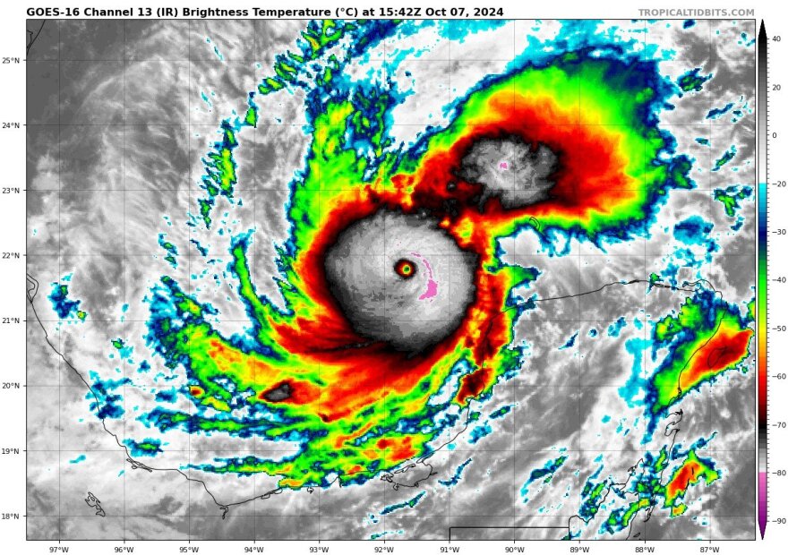
NEW AS OF 11AM: Milton is now a Category 5 hurricane. More strengthening is possible in the next day or so. Storm Surge and Hurricane Watches are issued for parts of Florida’s west coast and as of 11AM, hurricane watches have been extended into many inland counties.
A state of emergency has been declared for 51 out of Florida’s 67 counties. Milton is roughly 720 miles SWS of Tampa, Florida.

The National Hurricane Center says Milton is still moving east-south eastward at about 9 mph. Global models continue to insist that Milton will turn eastward soon as the low pressure area over the northeastern Gulf of Mexico leaves the region. Milton is expected to be a major hurricane and impact hurricane weary Florida on Wednesday.

Milton is expected to cross the State bringing widespread impacts to the west coast of Florida first, then to inland counties and eventually a large swath of eastern Florida.

Milton is expected to have winds near 125 mph as it approaches the central Gulf coast of Florida. However, Milton is expected to encounter a much less favorable environment with strong shear and dry air.

Some weakening is anticipated before the hurricane reaches the Florida Gulf coast. However, the system is still likely to be a large and powerful hurricane at landfall with life-threatening hazards at the coastline and well inland. Milton is expected to bring dangerous flooding across many parts of Florida this week. Rain estimates between 8-12 inches are possible in some areas over the coming days.

It’s too early to pinpoint the exact location Milton will make landfall. Minor fluctuations to the north or south of the current path will have large implications for Milton’s ultimate landfall and impacts.

While some weakening is anticipated, Milton is expected to transition into a larger (in size) hurricane at landfall, with impacts spreading over most of Florida as it bisects the State.
#Milton is now forecast to become a Category 5 #hurricane and reach a max intensity of 165 mph. If that forecast verifies, it would be the strongest Gulf of Mexico hurricane this late in the calendar year in the satellite era (1966-onwards). pic.twitter.com/WvJFsZzMBD
— Philip Klotzbach (@philklotzbach) October 7, 2024
Key Messages from the National Hurricane Center:
1. Damaging hurricane-force winds are expected across portions of the northern coast of the Yucatan Peninsula. A life-threatening storm surge with damaging waves is also likely along portions of the northern coast of the Yucatan Peninsula.
2. There is an increasing risk of life-threatening storm surge and damaging winds for portions of the west coast of Florida beginning Tuesday night or early Wednesday. Storm Surge and Hurricane Watches are now in effect for portions of the west coast of the Florida Peninsula and residents in that area should follow any advice given by local officials and evacuate if told to do so.
3. Areas of heavy rainfall will impact portions of Florida today well ahead of Milton, with heavy rainfall more directly related to the system expected later on Tuesday through Wednesday night. This rainfall will bring the risk of considerable flash, urban, and areal flooding, along with the potential for moderate to major river flooding.

Evacuation orders have begun in western central Florida including parts of Hillsborough, parts of Pinellas, Pasco, Sarasota, Hernando and Manatee counties. More counties will be added over the next 24-48 hours. Florida residents should have their hurricane plan in place, and follow subsequent forecasts and official notices or evacuations. Weather conditions will start to deteriorate for parts of western Florida on Tuesday, with the worst of the weather building early into Wednesday.

As always, only get your weather information from trusted sources. And be prepared to act quickly, if you are in an evacuation zone and are told to leave.
Copyright 2024 Storm Center


