

-
 Milton continues as a very powerful hurricane, track still shifting, residents along the path should be in an evacuation shelter or sheltered in place.
 -
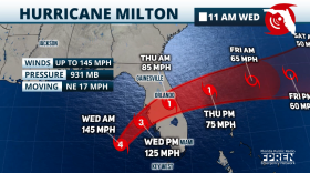
 Sarasota should monitor Milton's track closely. Milton could come ashore a bit more south than previously forecast.
 -
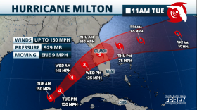 Milton is starting to leave northern Yucatán and head to Florida. It will move a bit faster today, and the powerful hurricane is expected to make landfall in Tampa Bay around midnight Thursday.
 -
 Residents are urged to complete their hurricane preps as Milton will start to indirectly affect western central Florida on Tuesday.
 -
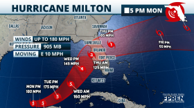 Milton has reached 175 mph maximum sustained winds as it nears the northern portion of the Yucatan Peninsula. Florida's landfall is expected on Wednesday.
 -
 Dangerous Category 5 Milton getting stronger, advisories issued, initial impacts expected by TuesdayMilton is a dangerous Category 5 hurricane. Floridians need to finalize preps by Wednesday.
 -
 Hurricane weary Florida is preparing for powerful Milton. Milton is expected to impact western central Florida on Wednesday.
 -
 Hurricane Milton will continue to intensify quickly and is expected to become a major hurricane, making landfall on Wednesday in Florida´s West Coast.
 -
 Milton is rapidly intensifying and is expected to be a major hurricane as it approaches west central Florida by Wednesday.
 -
 Milton is gathering strength and is expected to be a major hurricane as it approaches west central Florida by Wednesday.


WGCU is your trusted source for news and information in Southwest Florida. We are a nonprofit public service, and your support is more critical than ever. Keep public media strong and donate now. Thank you.