-
 Hurricane Lee is expected to stay off the U.S. East Coast this week, but that could change for the upcoming weekend.
 -
 Senior meteorologist Megan Borowski gives an update on what Southwest Florida can expect from Idalia.
 -
 Compilation of information in advance of a likely hurricane
 -
 Latest NHC forecast for Idalia has landfall on Wednesday as a Category 2 hurricane somewhere along the Florida Gulf Coast. Hurricane, Tropical Storm and Storm Surge Watches are now posted. The cone extends from near Panama City/Tallahassee through Sarasota, but remember Hurricane Ian hit outside the early cone forecasts.
 -
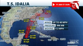 Tropical Depression Ten has now intensified into Tropical Storm Idalia. The NHC is forecasting landfall as a Category 1 hurricane (winds up to 90 mph) along the Florida Gulf Coast on Wednesday.
 -
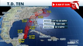 The declaration was made on Saturday and is intended to give communities as much time as possible to prepare for a impacts from a tropical system next week. Tropical Storm Idalia formed shortly after 11 a.m. on Sunday according to the National Hurricane Center in Miami.
 -
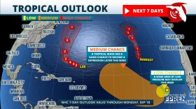
 The National Hurricane Center is now marking a spot from the northwest Caribbean into the eastern Gulf of Mexico with a moderate chance for development. Tropical Storm Franklin is now becoming better organized will likely become a hurricane over the weekend.
 -
 Hurricane season for people on the East Coast is a familiar six-month-long event, but for people on the West Coast, seeing a tropical cyclone is an unusual site.
 -
 Tropical Storm Harold made landfall on Padre Island late this morning with max sustained winds of 50 mph. Franklin is still forecasted to turn into a weak hurricane this weekend.
 -
 After several locations in Florida, including Key West, Fort Myers, Miami, Tampa and Sarasota recorded their warmest month on record in July, the Southeast Regional Climate Center is predicting that more records may be broken again this month.

© 2025 WGCU News

PBS and NPR for Southwest Florida
Play Live Radio
Next Up:
0:00
0:00
Available On Air Stations


